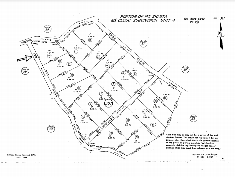
A beautiful treed land nested in the off-grid community of Mt. Shasta Forest, this gently sloped lot will give you the feeling of privacy with the convenience of being centrally located so you get the best of both worlds. Enjoy some beautiful landscape and views at the property while having the opportunity to experience the adventures surrounding Mt. Shasta Forest. The location is close to the historic town of Mc Cloud, Mt Shasta Ski Park, McCloud Reservoir, McCloud River, and Lake Siskiyou.
Did we mention that a well is already in place for your own private water source? Whether you’re looking for adventure or relaxation, this land has got you covered, so check this out and experience the adventure this property has to offer.
Download our property brochure for more information, including zoning, camping, RV, and building info!
Property Details:
Acreage: 2.51
County: Siskiyou
State: California
Parcel ID: 101-301-140-000
Google Maps: http://www.google.com/maps/place/41.341475,-122.073470
Zoning: R-R-B
View County/Property Zoning Info Here: https://library.municode.com/ca/siskiyou_county/codes/code_of_ordinances?nodeId=TIT10PLZO_CH6ZO
Annual Taxes: $339.76
HOA: Mount Shasta Forrest
Annual HOA Fee: $100 transfer fee for the the HOA and $500 annual dues (paid through 2021)
Access Notes: Easy access using the GPS coordinates. This lot is located on the corner of Winding Way and Echo Way.
Terrain Notes: Healthy mature trees and forested area with a gentle slope.
Utilities Notes: There has been a well installed on the property already! See copies of permits/etc. in the photos section above.. No other utilities are on the property as far as Wilco knows.
ADDITIONAL INFORMATION:
Buildable (Y/N) – Yes. Refer to Sec. 10-6.4802. – Uses permitted and Sec. 10-6.4803. – Conditional uses permitted in zoning details.
Mobile Homes Allowed (Y/N) – One mobile home per building site in lieu of a single-family dwelling.
Camping Allowed (Y/N) – Yes. Permit required.
RVs Allowed (Y/N) – Not specified. Permit required.
Location Details: Use this link to view the parcel outline on Google Earth/Maps: https://drive.google.com/file/
- Center Coordinates: 41.341475, -122.073470
- NW Corner: 41.341878, -122.074421
- NE Corner: 41.341851, -122.072972
- SE Corner: 41.341537, -122.072526
- SW Corner: 41.341015, -122.073812
Don’t know how to use GPS coordinates? Here’s a quick tutorial I made: link
Contact Miles McLaughlin at 605-250-1256 or email [email protected]
Our customers partner with Wilco Land for their land investments, because we’re different from other land sellers. We offer:
- Seller financing: Low down payments, flexible terms, and no credit checks
- Education and guidance: Free 1-on-1 consultation, property videos, educational blog posts, training, and market reports to give you the knowledge and confidence to make the right land investment.
- You can grow with us. We offer a land upgrade program, referral program, and more than one person has made money flipping our properties.
*This information is reliable but not guaranteed. Neither Wilco LLC or it’s associates are responsible for the accuracy of this information. Customers are responsible for all necessary due diligence pertaining to a purchase. Rural, undeveloped land can be dangerous due to terrain, poor or non-existent road access, etc. and calls for caution when visiting. Wilco will not be held responsible for any action or outcomes by visitors to our property.


I am seriously interested in this one Miles. Off grid means no utilities does it not? the thing is, may one build or not? Are there any neighbours already close by/adjoining properties?